ICE: Storing vectors in a color at vertices property


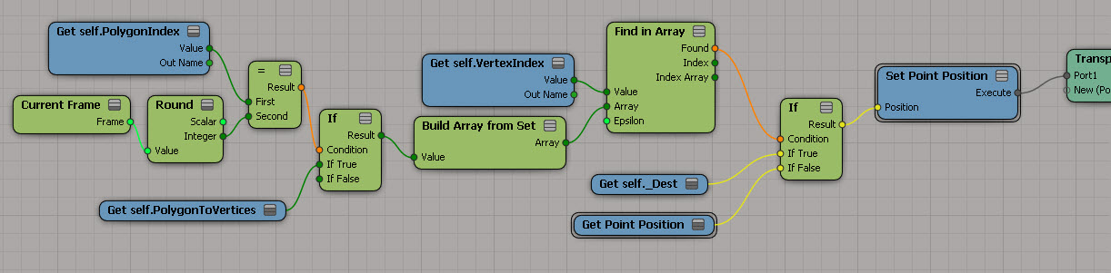
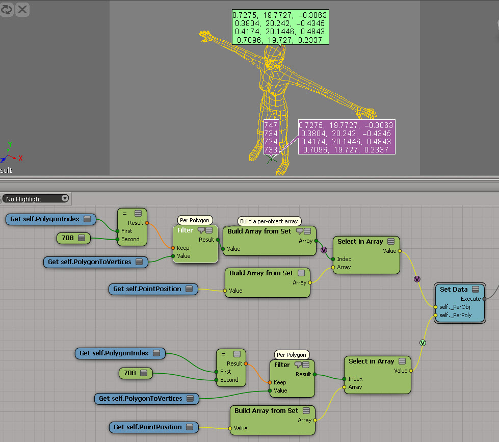
The ICE trees for something suggested by Pooby in this Storing initial values thread on si-community. In this example, I’m trying to store per-point data into a per-sample attribute, so I have do a little extra work. I’m actually storing the point position multiple times for each vertex (one vertex had N samples), but I don’t know if it’s worth the effort to try and avoid that.
StoreVectorInCAV

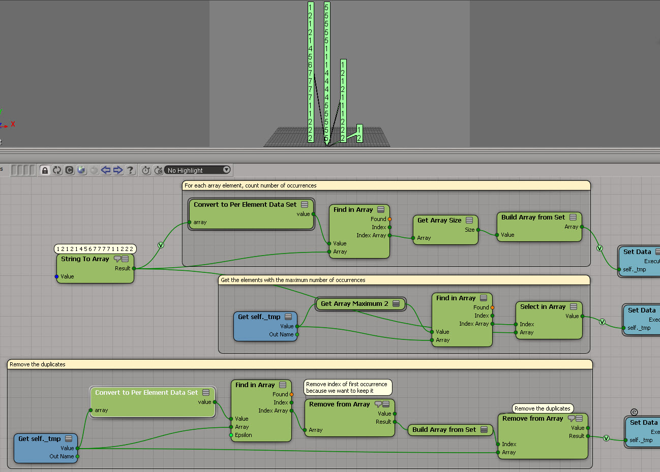
Getting the stored vectors back out:
GetVectorFromCAV

Finding degenerate polygons by area


Degenerate polygons are usually zero-area polygons.

Here’s a script that uses the ICE attribute PolygonArea to find polygons with area less than a specified epsilon:

si = Application
epsilon = 0.00001

# Get PolygonArea DataArray (which is a tuple)
attr = si.Selection(0).ActivePrimitive.GetICEAttributeFromName( "PolygonArea" )
areaData = attr.DataArray

#
# Find the indices of the bad polys
#
bad = [ x for x,y in enumerate( areaData ) if y < epsilon]

# Select the degenerates with a string like 'cube.poly[112,114,155]'
si.SelectGeometryComponents( 'cube.poly[%s]' % ','.join(str(i) for i in bad) )


### OR ###

#
# Get the actual Polygon objects
#
polys = si.Selection(0).ActivePrimitive.Geometry.Polygons
bad = []
for i in range( len(areaData) ):
	if areaData[i] < epsilon:
		bad.append( polys(i) )

si.SelectObj( polys )

Getting the DataArray2D for the Materials ICE attribute


Here’s the Python way:

Application.SelectObj("Pedestrian_Mesh.Actor_Copies", None, None);
o = Application.Selection(0)

a = o.ActivePrimitive.Geometry.GetICEAttributeFromName("Materials")
print len(a.DataArray2D)
print len(a.DataArray2D[0] )
print a.DataArray2D[0][0]
for s in a.DataArray2D[0][0]:
    print s

# 1
# 1
# (u'', u'Sources.Materials.PedestrianLib.Shoes', u'Sources.Materials.PedestrianLib.Hair', u'Sources.Materials.PedestrianLib.Legs', u'Sources.Materials.PedestrianLib.Skin', u'Sources.Materials.PedestrianLib.Shirt')
# Sources.Materials.PedestrianLib.Shoes
# Sources.Materials.PedestrianLib.Hair
# Sources.Materials.PedestrianLib.Legs
# Sources.Materials.PedestrianLib.Skin
# Sources.Materials.PedestrianLib.Shirt

And here’s how to do it in JScript:

o = Selection(0);

a = o.ActivePrimitive.Geometry.GetICEAttributeFromName("Materials");

x = new VBArray( a.DataArray2D ).toArray();
y = new VBArray( x[0] ).toArray();
for ( var i = 0; i < y.length; i++ )
{
    LogMessage( y[i] )
}

ICE: Finding the array elements that occur the most frequently


Another example usage of Generate Sample Set instead of Repeat. This time, the problem is to find the array element with the most occurrences. This seems kinda long winded (it’s a three-step process), but it does handle the case where you have two or more elements that occur the same number of times.

FindMaxOccurrences

I used a temporary attribute for formatting purposes (so I didn’t have one big long horizontal tree). And I used a compound to encapsulate the bit that takes an array and converts it to a “per generated element” data set:
ArrayToPerElement

If you want, here’s a compound version.

ICE: Removing duplicates from arrays


Here’s an ICE tree that removes all duplicate elements from an array. It uses Generate Sample Set, so there’s no repeat nodes. But it relies on the fact that you can feed in an array of indices into Remove from Array, and Remove from Array doesn’t care if that array of indices itself contains duplicate. So, if you plug the array [1,1,1,2,2,2,3,3,3] in the Index port, Remove from Array will nicely remove elements 1, 2, and 3 with no complaints.

GenerateSampleSet_Remove_Duplicates

Unlike some other methods, this works with scalars too:

GenerateSampleSet_Remove_Duplicates_Scalar

Use Global Coordinates for Display


Sometimes it can be useful to turn on Use Global Coordinates for Display. Because otherwise you’re going to be looking at points in local space, and that can mess up your thinking.

Here’s a simple example to show the difference. Purple is global, light green is local. As you can see, the purple points match up with the actual coordinates.
UseGlobalCoordsForDisplay

Now here’s a better example of the usefulness of Use Global Coordinates for Display. Red is local (and misleading). Yellow is global. Imagine you’re doing all kinds of coordinate system conversions in a complicated tree, and then you decide to show values as points. If you’re not careful, like me sometimes, you end up doubting everything you’ve done and pulling it all apart.
UseGlobalCoordsForDisplay1

PolygonPosition is read-only


Too bad, I had such big plans for this 🙂
PolygonPosition_red

So, now that I’m at a dead end, let’s go over the different ways to figure out why a node is red…

Point to the node and wait for the tooltip to show the first error:
PolygonPosition_tooltip

Right-click the node and click Show Messages.
(Log port type details can be useful sometimes, but not in this particular case.)
ShowMessages

Read the documentation.
PolygonPosition_doc